Ina (river)
Appearance
This article needs additional citations for verification. (November 2024) |
| Ina | |
|---|---|
 | |
 | |
| Location | |
| Country | Poland |
| Physical characteristics | |
| Mouth | |
• location | Oder |
• coordinates | 53°32′03″N 14°38′08″E / 53.5342°N 14.6356°E |
| Basin features | |
| Progression | Oder→ Baltic Sea |
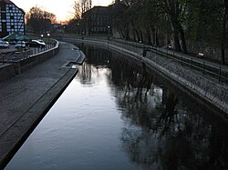
The Ina (German: Ihna) is a river in northwestern Poland, a right tributary of the Oder River.[1]
The origins of the river are in Insko Lake (Polish: jezioro Ińsko), and it flows through a succession of smaller lakes. The confluence of Ina River is localized in Police town, near Szczecin.[citation needed] It has a length of 129 km, and the basin area of the Ina is 2189 km2.[1]
The main towns situated on the Ina River are:
- Ińsko
- Goleniów
- Stargard with the famous Stargard Mill Gate
- Police, Poland (on the confluence of Ina River into the Oder)
In Pomeranian history, the Ihna from 1295 to 1464 separated Pomerania-Stettin and Pomerania-Wolgast. In the 16th century, it was one of the first European rivers to have its channel straightened, and was an important shipping artery up to WWII. Tributaries of the Ina are: Krępiel, Mała Ina, Reczek, Struga Goleniowska.
See also
[edit]References
[edit]- ^ a b Nędzarek, Arkadiusz; Tórz, Agnieszka; Bonisławska, Małgorzata; Gajek, Anna; Harasimiuk, Filip (2015). "Water Quality in the Central Reach of the Ina River (Western Pomerania, Poland)" (PDF). Polish Journal of Environmental Studies. 24: 207–214. doi:10.15244/pjoes/26971. ISSN 1230-1485. Retrieved 16 November 2024.

