Halle (region)
Appearance
You can help expand this article with text translated from the corresponding article in German. (August 2013) Click [show] for important translation instructions.
|
Halle
Regierungsbezirk Halle | |
|---|---|
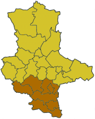
 Map of Saxony-Anhalt highlighting the former Regierungsbezirk of Halle | |
| Coordinates: 51°28′00″N 11°58′00″E / 51.4667°N 11.9667°E | |
| Country | Germany |
| State | Saxony-Anhalt |
| Disestablished | 2004-01-01 |
| Region seat | Halle |
| Area | |
• Total | 4,430 km2 (1,710 sq mi) |
| Population (1999) | |
• Total | 876,132 |
| • Density | 200/km2 (510/sq mi) |
Halle was one of the three Regierungsbezirke of Saxony-Anhalt, Germany, located in the south of the country.
History
[edit]It was founded in 1952 while part of East Germany. Becoming effective on January 1, 2004, the Regierungsbezirk was disbanded. Its functions were taken over by the Landesverwaltungsamt, which has three offices at the former seats of the Bezirksregierungen.
Subdivisions
[edit]Kreise
(districts)
(districts)
